Trip Description
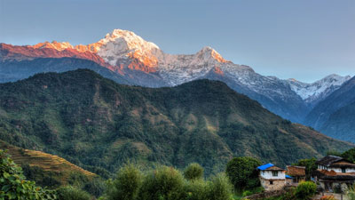
Trek encircles the popular Annapurna Ranges and Pass through with a great extent of environment and foliage on the tropical diversity of the Tibetan Plateau. An out of this world of Mt. Annapurna Ranges and Mt. Dhaulagiri Ranges are incredible. The higest ridge to this route Thorung-La Pass 5416m. is a challenge to the trekkers. Those trekkers having a preference in doing this treks require a sound health having enormous physical strength with immense of stamina. What is more definitely an opportunity to study on some of the ethnic groups who have been dwelling in these surroundings.
Trip Itinerary
Trip Itinerary
Day 01: Arrival in Kathmandu . Welcome clients at the airport and trasfer to hotel and check-in. A short briefing on the program after refreshment.
Day 02: Full day sightseeing two medieval cities in Bhaktapur and Patan.
Day 03: Kathmandu/Dumre 440m. to Bensisahar 790m. A distance of 137km from Kathmandu to and continuously ahead of Bensisahar wearyingly long drives. Pack lunch while traveling and after being reached at Beshisahar {trek starting point} cook prepares the dinner and rest at the camp set in the neighborhood of the Beshisahar.
Day 04: Bensisahar to Bahundanda 1310m. In the starting of walk trail drops down to the lower subsequently make a start go up to Khudi 790m. Gurung Village. Comes into sight of Mt. Himalchuli 7893m. and Peak 29 (Ngadi Chuli) during the trek and trail begins with a slight climbing that leads toward Bhulbhule 825m.Trail includes Bhulbhule 856. Ngadi and Lampata 1135m. and lastly camp at close to Bahundanda.
Day 05: Bahundanda to Chyanje 1400m. An easier trail of descending walk to Syange 1070m. continues to cross a suspension bridge over Marsyangdi River headed for Jagat a stony village. After a gradual climbing track that turn up little strenuous walk eventually ends at Chyanje 1400m. after a passing a jungle where does the crew fix the today's camp.
Day 06. Chyanje to Bagarchhap 2160m: Rock-strewn trails walk off the Marshyangdi River and mounts to Tal 1675m. first time after trek village emerges in this route. A widen and flat valley on the route leaves behind when some ups and downs of rocky stairways trail meet at the point of Dharapani 1890m. a settlement of Tibetan tradition than comes up at Bagarchap 2160m. houses are traditionally constructed having fla-roofed entirely Tibetan-styled.
Day 07: Bagarchhap to Chame 2685m. Trail on the route are time and again rough and rocky, which goes up to Tyanja 2360m. keep continue going in the direction of Chame 2685m. after passing through a forest near by a river and Kopar 2590m. Chame is sprawling headquarers of Manang district with the tempting view of Annapurna II 7937m. and other mountain peaks offers an opportunity for a springs bath located close to Chame town.
Day 08: Chame to Pisang 3186m. Trail proceeds through profusely forested area that enters into a steep and narrow valley and crosses a river with a long bridge 2910m. in a little while another bridge 3040m. A sight of Paungda Danda rock face is mind-boggling that revitalizes in physial strength to get into to Pisang sprawling with a distance between 3200m. to 3300m.
Day 09: Pisang to Manang 3535m. The trail goes from now through the drier upper region of the Manang district. There is an alternative trail from Pisang that leads to the north and south of the Marsyangdi River and converge at Mungji eventually. One route go through southern via Ongre with an airstrip 3325m. while another northern route go through Ghyaru offers a better views. Pushing along continuously comes up a scenic Bryaga 3475m. thronging with a number of hotels and restaurants.
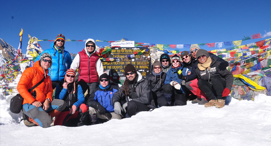
Day 10: Manang 3535m. One-day acclimatization in getting physically fit on crossing the Thorong-La Pass. What's more is an exploring in Manang surroundings having the time at one's disposal. Particularly an exercise is highly recommended which is compulsory while crossing Thorung-La Pass 5416m. back to the camp after ativities.
Day 11: Manang to Ledar 4250m. When trek starts from Manang and continues ascending a ranging height of 2000m. and route increases in the direction of Tengi 3645m. leaving Marshyangdi Valley with a slight climbing out then trail turs off northen west to Jarsang River Valley . Today's trek ends at Ledar {Lothar locally pronounced} after passing though a sparser forests of jeniper and barberry and pastures for Yaks and horses.
Day 12: Ledar to Phedi 4420m: A walk starts continue climbing along the eastern bank of Jarsang River and another wooden bridge 4310m. over a stream and again goes up to Phedi 4420m. a rock-strewn lowland delimited by precepitious cliffs. Hotels and loddges get over crowded of tourists in case of unfavorable weather for crossing Thorung-La Pass. Some trekkers might have distict possibilities on symptoms of alititude sickness if so an immdediate descends is highly suggested for a natural treatment and rest.
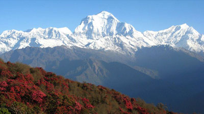
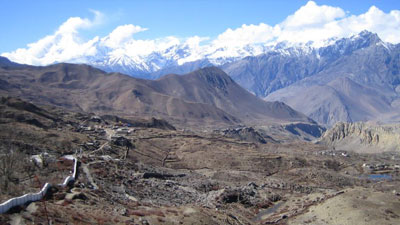
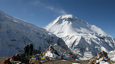
Day 13: Phedi to Muktinath 3802m. In native tonge Phedi translates 'foot of the hill' walk starts with steep path just before Thorong-La Pass 5416m. After a safe crossing of the Pass trek continues with a descending walk to Muktinath. In case of an unsuccessful on this crossing no way except retreat back to Beshisahar/Dumre or wait until the weather becomes appropriate for the trip. Some teashops and restaurants are available recently just after crossing the Thorung-La Pass. A view from Thorung-La Pass 5416m. with its traditional prayer flags and manes { piles of inscripted stones} the ranges of Mt. Khatungkang 6484m. Mt. Annapurna South 7219m. Mt. Gangapurna Yakgawakang 6481m. including a weird Kaligandaki Valley at below are thrilling in reality. Finishing an audacious traverse of 6/7 hours camp at Muktinath.
Day 14: Muktinath to Jomsom 2720m: A nice choice of trip to Kagbeni 2810m. a mediaeval village is unavoidable. When it completes immediately route goes along the Jomsom 2713m. Trans Himalayas Tibetan plateau a famous for availability of 'SALIGRAM' a fossilized black remaing substance of marine creatures of millions years ago. Apart from this Jomasom is the headquarters of Mustang district a thriving village. Mustang Apple Husbandry, Marpha Distillery, Mustang Eco-Museum are the barest outlines of the development of Jomsom.
Day 15: Jomsom to Kalopani 2530m. An inclusion of river valley trail continues to southern direction from Jomsom heading to Marpha 2650m. a Thakalese inhabitants proceeding forward to an agricultural project until Tukche village 2580m. Then route turs off to the western course trail passes to Khobang 2560m. than after a short walk arrived at Larjung 2520m. After leaving Sokung 2591m. behind on the way lastly arriving at Kalopani camping rest.
Day 16: Kalopani to Tatopani 1220m. A short walk from Kalopani of 20 minutes without delay approached at Lete 2438m. with a view of Mt. Dhaulagiri and Mt. Annapurna Ranges . further on Kali Gandaki and goes ahead in an ascending order to Bamboo Jungle. A relaxing trail starts from the jungle when it descend down to Lete River again comes into littles tougher while walking up through forest of Ghasa 2013m. The height declines on the way to Dana 1446m. as the following walk comes down gradually leaving behind Sukebagar, Guite, Jhartare ultimately at Tatopani 1220m.
Day 17: Tatopani 1220m. A literal meaning of Tahopani is 'HOT WATER' locally and of the essence this place is prevalent for the spring bath. This day will be relaxing and enjoyable by an explorations of the contiguous with the neighborhood of Tapotani.
Day 18. Tatopani to Ghorepani 2855m. A slight up going trail starts from Tatopani reaches at Ghara 1768 after crossing a suspension bridge over Kali Gandaki River. still keeps continue ahead of Shikha 2012m. a Magar village mostly in-service military and retired from the British and Indian armies. Going in average through the forested pathway that approaches a Pass of height 2830m. from where the sight of Mt. Dhaulagiri and Mt. Annapurna South 7219m. can be seen if fair weather and trek last at beautiful Gaorepani, locally known as 'GHODEPANI' meaning 'horse and water'.
Day 19: Ghorepani to Birethani 1037m. An early morning excursion trip to Poon Hill 3210m. will be an unforgettable moment in one's lifetime as it is considered to be the best tourist point in Nepal to view the almost all mountains that ranges from east to west. Spending few moments at this point walk begins with dropping down to Modi River Valley then after hike repeats a steeply descending trail through jungle to Nayathanti 2510m.entering into Ulleri 2070m. From Ulleri trail goes down to join Bhurundi River 1580m. then Tirkhedhunga 1500m. ahead Hille and come into sight of a sprawling village on the bank of Modi River Birethanti 1040m.
Day 20: Birethanti /Nayapul to Pokhara 850m. Last day of trek that starts in the morning and after few hours of walk leads to Nayapul. After Nayapul a transport for pick up will be waiting you then drives back to Pokhara and check-in hotel.
Day 21. Full day Pokhara sightseeing around Pokhara City .
Day 22: Fly or drive back to Kathmandu and check-in at the hotel.
Day 23: Whole day free in the evening a farewell dinner.
Day 24: Transfer to airport for final departure.
Cost Includes/Excludes
Cost Includes
- Trekking guide
- Trekking permit
Cost Excludes
- Nepal Visa fee
- International Air fare
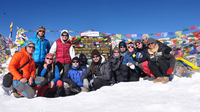
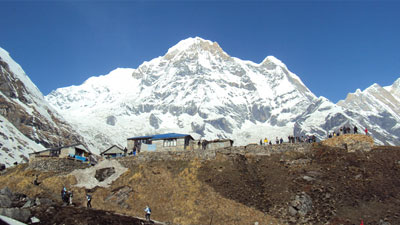
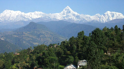
Trip Photos
Please click on small photos to have larger view!