Trip Description
Dolpo a conservancy area of Shey Phoksundo National Park lies in far western region of Nepal into a boundary of Mt. Dhaulagiri Range in the east and south Churen Himal ranges and Dunai and in the west Jumla district. This area is absolutely isolated land of the country was not opened for trekkers before 1989. has been opened for trekking upon a payment of US $ 700.00 as permit fee for 10 days seems relatively expensive to other sectors.
Trip Itinerary
Trip Itinerary
Day 01: Arrival in Kathmandu . Welcome clients at the airport and trasfer to hotel and check-in. A short briefing on the program after refreshment.
Day 02: Full day sightseeing two medieval cities in Bhaktapur and Patan.
Day 03: Sarangkot 1585m. 2/3 hrs climb. Site of an old fort (KOT) an outstanding view point. Trek starts with a short drive to Bindeswari Temple and then it is a 2/3 hrs climb to Sarangkot. From here the Annapurna I 8091m. visible behind Annapurna range stretches east with Machhapuchhre {The Fish tailed} dominating the Pokhara Valley and Manaslu 8156m. and Hiunchuli also visible.
Day 04: Salyan 1615m. Walking 1 hour the trail traverses along the southern slopes of the Kaski ridge below the crest. Pass Kaski village and after about 1 hour rach Maudanda 1450m a large village the main trade route leading to the Kali Gandaki, Mustang and Tibet join the trail from the Yangdi Khola here and pony/mule trains will be frequently met until we leave this trail and most other trekkers and contour south of Salyan.
Day 05: Dobila 1168m. Delightful morning walk through scattered Gurung Villages before dropping steepy through a forest of fine muture pine. After lunch near the large village of Tihar the route follows the line of the Madi River which drains the Annapurna Sanctuary down to Dobila. Camp near the river.
Day 06: Baglung 948 m. the Madi River is crossed by a good bridge and Kusma is reahed after a steady climb the trail now descends down to the bridge at Khaniyaghat below Baglung.
Day 07: Tatopani/Mayangdi River 945m. the trail follows the Kali Gandaki until the turn west up the Nayangdi River valley. Good river camp sites beyond the village not to be confused with its more famous name sake further up the Kali Gandaki valley.
Day 08: Dharapani 1524m. From Tatopani to Dobang the track keeps mainly on the north bank of the river but may cross to the south side a short distance beyond Tatopani recrossing late in order to avoid landslip on the north bank. At Darbang the Nayangdi changes courses and forms a dog's leg now flowing from north to south. The track crossed the river at Darbang from north to south. The track crossed the river at Darbang and keeps henceforth on the west side of the river. A side streams the Danga fiver providing a possible campsite is crossed 2 miles beyond Darbang and from there the track climb steeply to Dharapani. After 2 hrs gradual descent we approach Humri Bhanjyang market and again we gradually climb on a straight trail to Ramche and camp. From her you have good views of the Baudh Himal and Gorkha Himal.
Day 09: Lamsur 2195m. Passing Takum and Runa the track which has been running high above the river on the west side of the Nayangdi turns up the Dara River to Lumsum.
Day 10: Utter Ganga/Sinudat River 2743m. the trail runs up the side of the Lumum stream and then crosses it and climbs steeply passing the hamlet of Moreni. After 4 miles the track levels off at an altitude of 3345m and winds for about 2 miles past cattle pastures and a few huts before descending to the head of the Dhorpatan valley also know as the Uttar Ganga. From the high Jaljala ridge there are magnificent views of the whole of the Dhulagiri range this is one of the great day's walks in the hills of Nepal . Camp near the pass.
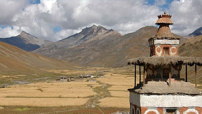
Day 11: Dhorpatan 3011m. the name Dhorpatan is applied to a collection of settlements lying along the valley of the Uttar Ganga, the largest being known as Nauthar, situated about 5 miles form the last campsite. Here there is an airstrip and there is also radio communication with Kathmandu . Formerly the Dhorpatan alley served mainly as summer pasture for the Magar and other tribesmen living in the valleys to the south in the late 1950s and early 1960s however a number of Tibetan refuses were settled her with the aid of Swiss Red Cross and it is now they who from the bulk of the permanent population this broad flat valley more or less unique is the tangled hills and the gorged country of Northern Nepal are well worth a visit. Under the plan now proposed this would be down in the day from the Uttar Ganga/Simidhar Khola campsite, returning for the night. Time can be spent around then Jaljala/Dhorpatan area as required.
Day 12: Phagunedhuri Pass 3963m. Walking 6/8 hrs. Leaving the valley of the Uttar Ganga River at Dhorpatan with its large settlements of recently established Tibetan villages the trail climbs northwards. Walking into the pine clad hillside the lat of the slate roof houses are left behind. The trail climbs steadily to the pass 3960m. From the pass the peaks of the Dhaulagiri massif on the far side at about 12,500ft is visible.
Day 13: Kyami Danda 3190m. from Phagunedhuri the trail drops through thick forest and an open glade at Thinkur of the Gustung river where lunch shoud have here as there is no water from here until camp. From the Gustung River the trail climbs steeply through forest to the ridgeline with views west towards the Bheri depression and northwards towards the snow clad mountains. The campsite as Kyani Danda is a small grassy opening on the ridgeline.
Day 14: Dulby 3202m. 6/7 hrs hike descend steeply to the village of Pelame with a primary school and about ten families or Kamis, Chhetris and Magars. A taste of the flat roofed architecture that is universal from here on can be seen the village of Yamkar 0on the opposite side above the Pelma River is reached in another hour. Lunch stop here or at the river below the trail to the villages of Malikot branches off towardst the west from here while the trail to Dulby climbs steeply to the ridge above Yamkhar. From the ridge descend slightly through forested hillsides to ascend again to tea shop of Dulby in a small clearing in the forest.
Day 15: Phupaldaha 4230m. 6 walking hrs leaving Dulby the trail climbs about 2000 ft. to Dulby Deurali and then drops into the Sheng Khola gorge. Follow the stream along the right bank up the tortuously carved valley through crumbling Shell Mountains . Lunch at a side stream coming off the hillside. The trail continues up the valley passing shepherds but and several streams to turn right leaving the river to climb to a small marshy lake called Phupadaha. This is the most beautiful campsite.
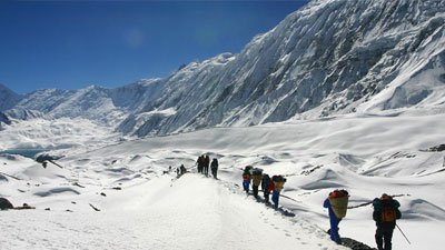
Day 16: Above Sahar Tara 3170m. Walking 8/9 hrs depends on snow conditions Leaving camp the trail climbs gradually for about 500 ft to Phupal bhanjyang. Now we are coming across the Dhaulagiri range with the Churne Himal just visible to the north. From here it is a two-mile gradual descent to the Saure river that also offers excellent camping sites this area is rich in wildlife like the blue sheep herds of which can be seen grazing on the mountains sides. Himalayan for another rare animal might also be seen around here. After crossing the Aure steram the trail climbs steadily for about 1500ft to the Jangla Bhanjyang at an altitude of 14400ft. Marked by the customary pile of rocks and player flag fluttering in the wild the pass cuts through a cleft between two hillocks. Below the pass the trail descends gradually to the Thanke Danda from where views towards the Kagmara range and further to the Kanjiroba Himal are very good the Bheri valley at Dunai and down to the right the villages around Tarakot are also visible. Continue down the tree line to camp in an opening well above the first village. Today's lunch can be served before the pass on the open grassy lawn by the stream or packed lunch served in snow bound conditions.
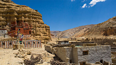
Day 17: Tarakot 2561m. Walking 3/4 hrs today's walk is a short but steep descent through Samthaling Gaun and Saharatara to Tarakot. Situated above the Barbung River these villages are inhabited by Kham Magars and ethenic group with quique traditions. With their flat rooted houses these villages are reminiscent of Pueblow Indian settlements. Camp can be set up directly below the village of Tarakot besides the small stream. From here the monastery of Tarakot is immediately behind and above the camp on a ridge and can be visited in the afternoon. Lunch at camp.
Day 18: Dunai 2042m. Walking 5/6hrs leaving Tarakot the trail descends west to the police post where trek permits might be inspected. Just below here cross the Barbung river by a suspension bridge continue first through cultivated hillsides and then along pine clad valley to Dunai. Dunai is the administrative headquarters of Dolpa district and has a police check post and other government offices. Camp on the riveside just outside the town. Lunch stop at a little stream enroute.
Day 19: Cherpa Villlage 2591m. Walking 8/9 hrs leaving Dunai the trail climbs immediately up the hillside to the north. The confluence of the Barbang River with Suligad can be can be viewed from above marking the two principal tributaries of the Thulo Bheri River that drains in to the great Karnali. Continue high above the Suligad to the village of Rohangaun . After lunch here continue descending slightly to the Army Post at Ankeny marketing the entrance to the Shey Phoksundo National Park . Camp can be set up at the single house settlement at Cherpa on fields or futher on under walnut trees in small clearing by the streamside.
Day 20: Reyaji Village 2927m. Walking 6 hrs the trail stays well above the river in the lush forest from there. The Suligad valley is forested by thick stands of Juniper trees probably the forest seen anywhere in Nepal . Lunch at the river and continue through the forest along the river to a bridge at Riyaji Village and inconspicuous settlement on the opposite bank where camp can be set up for the night.
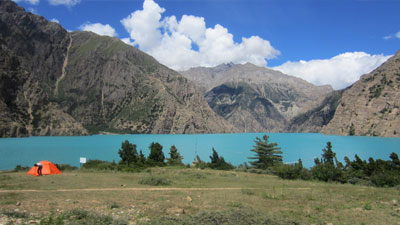
Day 21: Phoksundo Lake 3506m. Continuing along the left bank of the river the trail reaches the confluence of the Suligad with Pungmo Mala. Above here is the park headquarters and warden's office at a place called Sumdo where park entrance fees are collected. The road to Murwa Village is the opposite side crossed here by a wooden bridge. A little farther on lunch can be had by the river. After lunch the summer settlement of Palmo is reached in a short while. From here the trai starts to climb steeply towards Phoksundo and the great waterfall can be seen down below the trail from the top of this climb. The lake Phoksundo is seen in the depression beyond the great wall like ridge. The waters of this mountain lake is a deep blue formation that some call turquoise and others lapis lazuli? Camp past the village Ringmo on the southern shore by the river that drains the lake. The villagers here are followers of B'on the old shamanistic religion of Tibet .
Day 22: Pungmo village 3170m. Walking 4 hrs after a night at this wonderful campsite besides the clear waters of the lake we retrace out steps back down to Sumlo from where we will follow the trail north west up the Pungmo Nala to the small B'on village of Pungmo . Camp is there up near the village after a half-day's walk. Having luch ample of time to explore the village and the enthusiastic can visit the B'on monastery about two hrs walk up the hillside across the river from here.
Day 23: Below Kangmara Pass 4207m. Walking 6/7hrs from Pungmo the trail leads up the valley along the left bank to cross it about two hours from here to the right hand bank. Views of the Kangchunne and Kanjeilarwa peaks are very nice along today'walk. The valley is well forested with Juniper and birch and wild animals like the musk deer inhabit this area. Further up the valley blue sheep might be seen on the mountain slopes. The trail climbs steadily turning westward once above tree line and keeping high above the river. Camp is made on same level ground below the Kangmara pass at the altitude of 13,800ft.
Day 24: Kanglakpak 3353m. Walking 8/9 hrs depends on snow conditions. An early start climbing steadily uphill to the pass at an altitude of 16100 ft. From here the summits of Kagwara I towards the south is visible nearby and many other peaks of the range also are visible. Views west towards the Sisne and Patrasi Himal and northwards to Kanjiroba are striking. The trail descends steeply towards the west and a long downfall walk of about 5 hrs will bring us to a small campsite below the peak of Kangmara Valley. The river we have been following this afternoon is called Garpung River .
Day 25: Huyrikot 2652m. Walking 6 hrs following the Garpung Khola high above it along the right bank the trail turns north above the confluence with the Jagdulla Khola to descend down to the Army Check Post. After crossing the Jadulla khola to the right bank here the trail follows well forested valley to the village of Huyrikot where camp is set up for the night. Huyikot where people claim to be Chhetris of Rokai, Barwai, Burathoi and Thakuri families. Here also some Bhotes from Saldang spend the winter grinding maize at the water mills run by Kamis of the village.
Day 26: River Camp 3506m. Walking 6/7 hrs crossing the stream coming off the Jagdull Lekh a Huyrikot the trail goes up along the ridge to the northwest to climb Barbarey Lekh Pass at an altitude of about 12,500ft. This is a longish gradual climb and the pass itself is along ridgeline quite unlike most passes. Views north towards the Kanjiroba Himal are very fine from here. Descending into a dense forest of pine, spruce, fir and oak camp is made in a forest cleaning beside of the river flowing down the valley.
Day 27: Dillikot Village 2622m. Walking 6 hrs from camp below Barbarey Lekh follow the trail down stream through oak and pine forest to the village of Chorts also known as Napukuna past another small settlement of newly established village. After lunch trail continuing down stream the confluence at the Tila khola near Dillikot is reached in about 2 hrs here the trail turns right down the Tila stream and camp can be established on fine meadows past the village.
Day 28: Garjankot 2622m. Walking 6 hrs following the Tila stream the trail runs below the villages of Munigaun and the Kurigaun to climb up a side stream coming down from the left just short of Guthigaun climbing steadily the sheep farm at Guthichaur is reached in another hour here for lunch. Another half hour's walk will bring the trail descending steadily past line grazing grounds to the village of Garjankot once again above the Tila khola. There is a camping place above and below the village.
Day 29: Jumble 2317m. Walking 3 hrs a half day's walk along the wide Tila valley past paddy fields and the village of Dipayal brings the trek to Jumla town where camp is set up near the airstrip. After lunch there will be time to visit the town and relax at camp.
Day 30: Fly from Jumla to Nepalganj and Kathmandu .
Day 31: Half day sightseeing in Kathmandu and in the evening a farewell dinner.
Day 32: Transfer from hotel to the airport for final departure.
Cost Includes/Excludes
Cost Includes
- Trekking guide
- Trekking permit
Cost Excludes
- Nepal Visa fee
- International Air fare
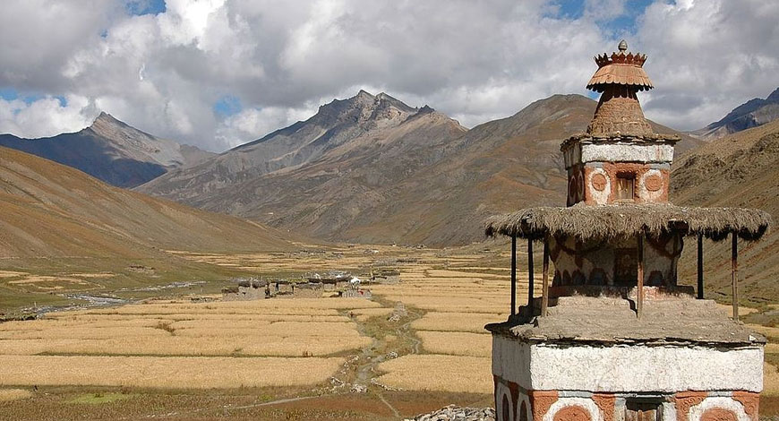
Trip Photos
Please click on small photos to have larger view!